
Recovery and Rehabilitation


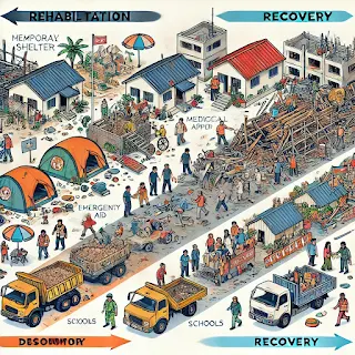
Disaster management involves several phases, including mitigation, preparedness, response, recovery, and rehabilitation. Recovery and rehabilitation are post-disaster activities that aim to restore normalcy and improve resilience in affected areas.


1. Recovery

Recovery is the long-term process of rebuilding communities, infrastructure, economy, and social systems after a disaster. It focuses on restoring normalcy while incorporating resilience measures to withstand future disasters.

  1. Short-term Recovery – Immediate efforts within weeks or months to restore essential services (e.g., water, electricity, healthcare, shelter).
  2. Long-term Recovery – Efforts that take months to years, including rebuilding infrastructure, economic revitalization, and mental health support.
  3. Resilience – The ability of a community to recover quickly and adapt to future disasters.
  4. Livelihood Restoration – Providing economic support to affected populations through job creation, skill training, and financial assistance.
  5. Psycho-social Recovery – Addressing trauma, stress, and mental health impacts of disasters.
  6. Infrastructure Reconstruction – Rebuilding damaged roads, bridges, hospitals, and schools.
  7. Economic Recovery – Providing financial aid, loans, and policies to restore businesses and agriculture.

Example

  • 2004 Indian Ocean Tsunami: Long-term recovery efforts included the reconstruction of houses, fishing boats, and economic support for affected communities.
  • 2015 Nepal Earthquake: The government and NGOs provided financial support, rebuilt schools, and restored tourism-dependent economies.

2. Rehabilitation

Rehabilitation is the process of restoring the physical, social, and economic conditions of an affected community to at least pre-disaster levels. It focuses on providing temporary solutions before permanent recovery measures are implemented.

  1. Temporary Housing – Setting up relief shelters or camps for displaced populations.
  2. Medical Rehabilitation – Providing healthcare, prosthetics, and therapy to disaster survivors.
  3. Social Reintegration – Reuniting displaced families and providing psychological counseling.
  4. Environmental Rehabilitation – Restoring ecosystems, clearing debris, and managing waste.
  5. Cash-for-Work Programs – Engaging affected people in rebuilding efforts by providing financial incentives.

Example

  • Hurricane Katrina (2005): Temporary shelters were set up, and medical rehabilitation was provided for injured victims.
  • Uttarakhand Floods (2013): Government agencies set up temporary housing and provided psychological counseling to affected families.

Differences

AspectRecoveryRehabilitation
ObjectiveLong-term rebuilding and resilienceShort-term restoration of essential services
TimeframeMonths to yearsDays to months
FocusInfrastructure, economy, mental health, sustainabilityImmediate shelter, healthcare, livelihood support
OutcomeSustainable development and disaster preparednessBasic functioning and stability

Comments

Popular posts from this blog

Geology and Tectonic. Indian Shield

1. Ch (Chattisgarh Basin): Chattisgarh Basin is a geological region in central India known for its sedimentary rock formations. It's important for its mineral resources, including coal and iron ore. 2. CIS (Central Indian Shear Zone): CIS is a tectonic boundary in central India where the Indian Plate interacts with the Eurasian Plate. It's characterized by significant faulting and seismic activity. 3. GR (Godavari Rift): The Godavari Rift is a geological feature associated with the rifting and splitting of the Indian Plate. It's located in the Godavari River basin in southeastern India. 4. M (Madras Block): The Madras Block is a stable continental block in southern India. It's part of the Indian Plate and is not associated with active tectonic processes. 5. Mk (Malanjkhand): Malanjkhand is known for its copper deposits and is one of the largest copper mines in India. 6. MR (Mahanadi Rift): The Mahanadi Rift is a geological feature related to the rifting of the Indian Pl...

Solar Radiation and Remote Sensing

Satellite Remote Sensing Satellite remote sensing is the science of acquiring information about Earth's surface and atmosphere without physical contact , using sensors mounted on satellites. These sensors detect and record electromagnetic radiation (EMR) that is either emitted or reflected from the Earth's surface. Solar Radiation & Earth's Energy Balance Solar Radiation is the primary source of energy for Earth's climate system. It originates from the Sun and travels through space as electromagnetic waves . Incoming Shortwave Solar Radiation (insolation) consists mostly of ultraviolet, visible, and near-infrared wavelengths . When it reaches Earth, it can be: Absorbed by the atmosphere, clouds, or surface Reflected back to space Scattered by atmospheric particles Outgoing Longwave Radiation is the infrared energy emitted by Earth back into space after absorbing solar energy. This process helps maintain Earth's thermal bala...

Neighbourhood Operations

 Neighbourhood Operations in GIS? In GIS and raster data , neighbourhood operations look at a group of nearby pixels (not just one) to understand or change a pixel's value. Think of it like checking what's around a house before deciding what color to paint it! Why "Neighbourhood"? Each pixel has " neighbours " (just like how your house has nearby houses). Neighbourhood operations check these nearby pixels and do some calculation to get a new value. 1. Aggregations (Summarizing Nearby Values) Aggregation means combining values of several pixels into one. We do this to: Find the average of surrounding pixels Find the minimum or maximum value Smooth the map (make it less rough) 🧒🏻 Example: Imagine checking the test scores of 9 students sitting around you and finding the average score . That's aggregation!  2. Filtering Techniques Filtering is used to improve or highlight features in a raster image, just like f...

Morpho-Tectonic Framework of India

The MorphoTectonic Framework of India refers to the combined study of the country's landforms (morphology) and its geological tectonic features. This framework provides insights into how geological forces have shaped India's topography over millions of years. Here's a breakdown of this concept: 1. Morphology: This aspect focuses on the physical features and landforms of India. It includes the study of mountains, plateaus, plains, valleys, rivers, and other surface features. For example, the Himalayas, Western Ghats, IndoGangetic Plains, and Deccan Plateau are prominent morphological features of India. 2. Tectonics: Tectonics deals with the movement and deformation of the Earth's lithosphere (the outermost rigid layer of the Earth). In the case of India, it primarily involves the interactions of the Indian Plate with neighboring tectonic plates. India is situated at the convergence of several major tectonic boundaries:     Collision with the Eurasian Plate: The most sign...

EMR Spectrum Remote Sensing

The Electromagnetic Radiation (EMR) Spectrum is like a set of invisible waves that carry energy. In remote sensing , satellites and sensors use these waves to collect information about the Earth —like forests, water, cities, clouds, temperature, and more. Just like how our eyes can only see visible light (like colors in a rainbow), sensors in remote sensing can "see" many more types of waves that humans can't.  Types of EMR Used in Remote Sensing: Type of Wave Wavelength What It's Used For Example Visible Light 0.4 – 0.7 micrometers To take normal satellite images Google Earth pictures Near-Infrared 0.7 – 1.0 µm To check plant health Green areas, farming Shortwave Infrared (SWIR) 1.0 – 3.0 µm To see moisture in soil and vegetation Drought or wetness studies Thermal Infrared (TIR) 8.0 – 14.0 µm To measure surface temperature Heat from buildings, forest fires Microwaves 1 mm – 1 meter To see through clouds and at night (radar) Flood detection, weather, disaster...